Odyssey counts neutrons and finds buried ice
Neutron counts fell away over both poles. Odyssey read that as ice within a metre of the surface — by one estimate enough to fill Lake Michigan twice, and a target for landers.
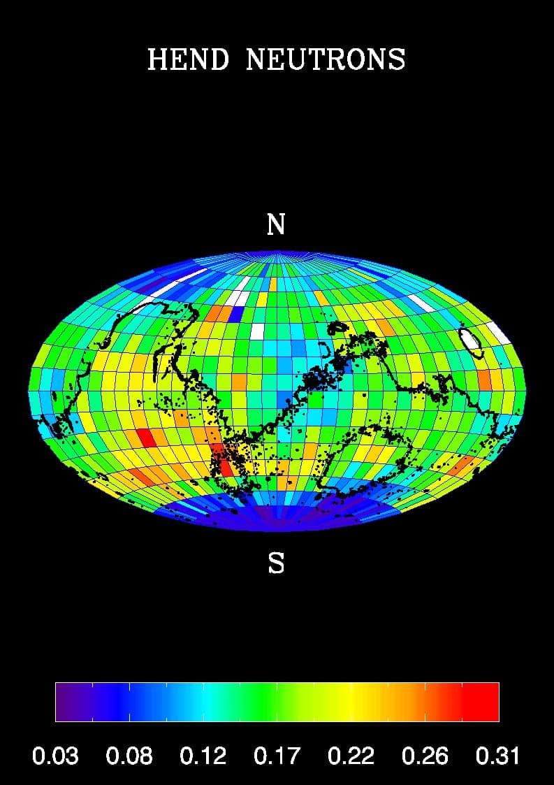
The signal was an absence. Cosmic rays strike Mars constantly and knock neutrons out of the top metre of soil; hydrogen, whose nucleus is almost exactly a neutron's mass, is uniquely good at draining their energy on the way back out. So hydrogen-rich ground returns markedly fewer moderate-energy neutrons than bare rock does. In early 2002, Odyssey's detectors began reporting a sharp shortfall across the southern high latitudes, and then across the north as its summer came around.
2001 Mars Odyssey had launched on 7 April 2001 — sixteen months after the second of the 1999 losses, and carrying a good deal of institutional anxiety with it — and entered orbit on 24 October. It aerobraked into a near-polar orbit about 400 kilometres up by January 2002. Its gamma ray spectrometer was really three instruments sharing a name: a germanium gamma subsystem led by William Boynton at the University of Arizona, a neutron spectrometer led by William Feldman at Los Alamos, and a Russian high-energy neutron detector built by Igor Mitrofanov's group.
On 28 May 2002 the team put numbers on it. Poleward of roughly 60 degrees in both hemispheres, under a desiccated layer a few tens of centimetres thick, the ground appeared to be 20 to 50 percent water ice by mass — more than half by volume. JPL translated that into enough ice in the top metre alone to fill Lake Michigan twice over.
It was an inference, not a sample. Neutrons cannot see much below a metre, and the instruments detect hydrogen rather than water, so hydrated minerals would look broadly similar. The case rested on the layered structure of the signal, on where ice ought to be thermodynamically stable, and on how sharply the effect switched on with latitude. Six years later Phoenix landed at 68 degrees north, scraped down five centimetres, and hit it.
Odyssey did other work — THEMIS mapped surface mineralogy and thermal inertia, and its MARIE radiation monitor stopped taking data after a solar storm hit the spacecraft on 28 October 2003 — but its most durable job turned out to be plumbing. It has relayed the bulk of the data from every NASA surface mission since Spirit and Opportunity, and it is still in orbit, the longest-running spacecraft ever to operate at another planet.