The Borealis impact splits Mars in two
The northern lowlands sit 5 km below the southern highlands. The boundary traces an ellipse 10,600 km across — plausibly the largest impact scar in the solar system.
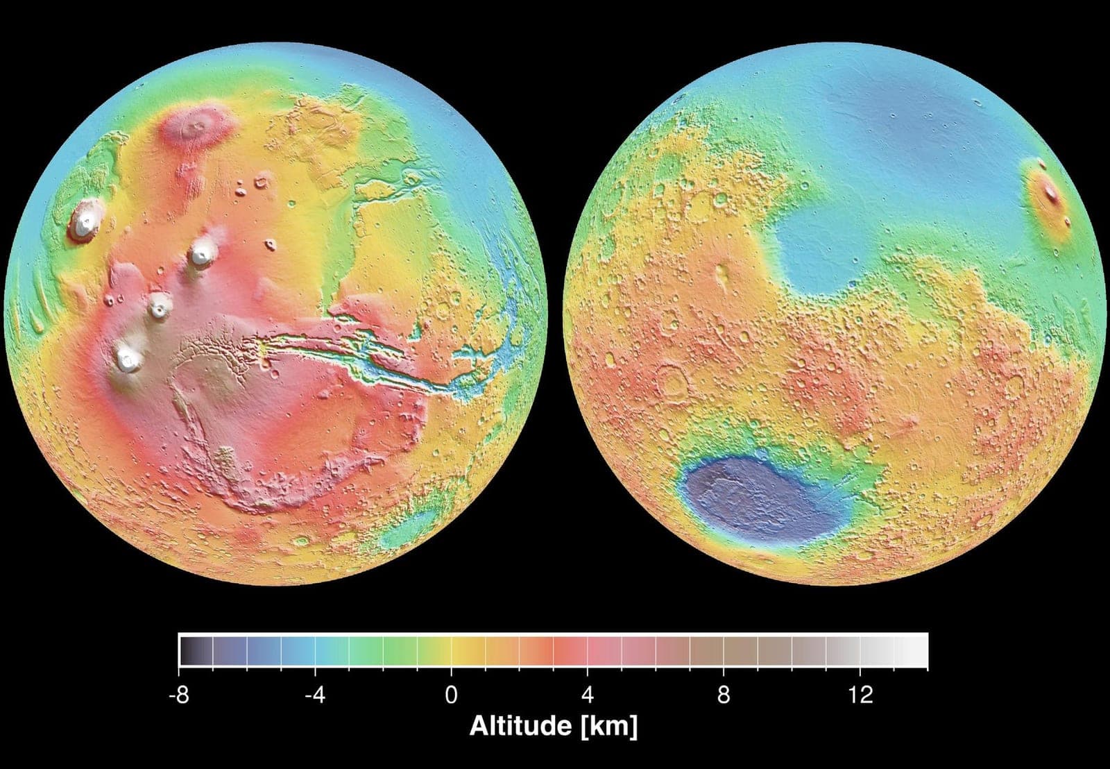
Draw a great circle around Mars and you cut the planet into two different worlds. The northern lowlands — roughly two-fifths of the surface — are smooth, low, thinly crusted and nearly free of large craters. The south stands 5 to 6 kilometres higher, is saturated with impacts, and carries crust something like 20 to 30 km thicker. Nothing else on Mars is remotely this big. Mariner 9 and the Viking orbiters saw the split in the 1970s. Explaining it took another thirty years, and the explaining is not finished.
The obstacle was Tharsis. The volcanic province that erupted later buries part of the boundary and warps the gravity field everywhere else, so the dichotomy could not simply be traced. In 2008 Jeffrey Andrews-Hanna, Maria Zuber and Bruce Banerdt modelled the Tharsis load and subtracted it, recovering the boundary underneath. What emerged was not a ragged line. It fit an ellipse roughly 10,600 by 8,500 km, covering about 40 percent of the planet — four times wider than Hellas, the next largest basin on Mars, and, if it is an impact scar, the largest one known anywhere.
An ellipse rather than a circle implies a glancing blow. In the same issue of Nature, Margarita Marinova, Oded Aharonson and Erik Asphaug ran the collision: a body 1,600 to 2,700 km across, striking at 6 to 10 km/s at an angle between 30 and 60 degrees, delivering on the order of 3 to 6 × 10²⁹ joules. That is an impactor the size of Pluto or larger, arriving while Mars was barely finished forming.
The melt is the crux. A collision that violent ought to melt a large fraction of the planet and flood the new basin with fresh rock, erasing the evidence of its own occurrence — the standing objection to every impact model since the idea was floated in 1984. Marinova's team answered it with geometry: at low velocity and a glancing angle, their melt stays inside the crater. Francis Nimmo's group, in the third of that issue's three papers, answered it by embracing it: they modelled a head-on strike and argued that impact melt is what the northern lowlands crust is made of, drawn from a deep, depleted mantle source that matches the shergottite meteorites. The two answers do not agree with each other.
The competing explanation skips the impact entirely: a single vast upwelling in the mantle, so-called degree-one convection, thinning the crust from below over hundreds of millions of years. That one struggles to produce an elliptical boundary. Neither side has won, and the dichotomy remains the biggest unexplained thing on the planet.
Whatever made it, the low half became the drain. Every valley network in the southern highlands runs downhill toward it. If Mars ever held an ocean, this basin is the bowl it sat in — which is why the argument about a martian ocean is always an argument about the north.